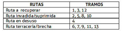
Plan D-01 | Original route
This map especifies the location of some heritage sites In the old railway route.
1.- Hacienda de Estipac
2.- Railway : Santa Ana station
3.- Hacienda La Sauceda
4.- Dirt road
5.- Railway route
1.- Hacienda de Estipac
2.- Railway : Santa Ana station
3.- Hacienda La Sauceda
4.- Dirt road
5.- Railway route
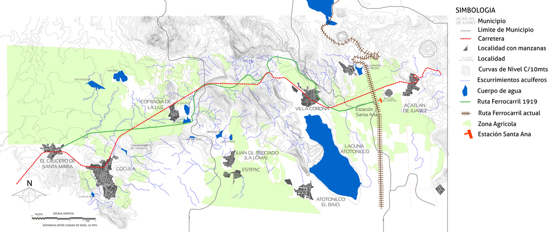
Plan D-02 | Photographic survey of the study area.
This map shows the most important Heritage sites in the study area as well as some important elements in the study area.
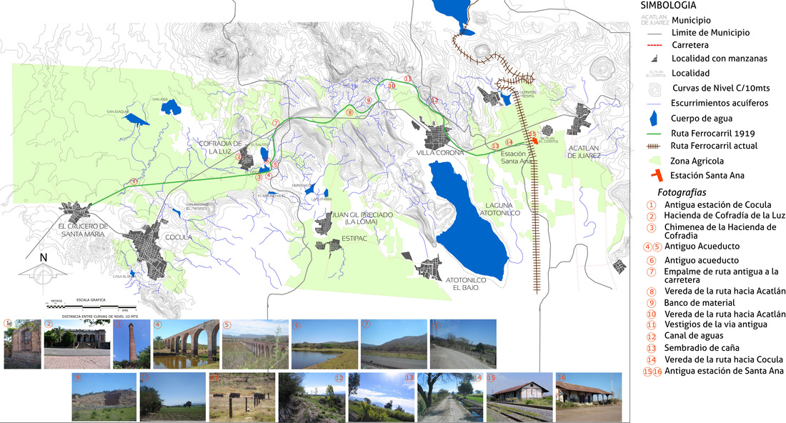
Plan D-03 | Existing Infrastructure
This map shows the information of the transformed context, including Infrastructure and facilities available of the study area. Includes information of:
Electric network
Telephone network
Existing railways
Warehouses
Agricultural areas
Temples
Rodeos
Spas and watersports
Electric network
Telephone network
Existing railways
Warehouses
Agricultural areas
Temples
Rodeos
Spas and watersports
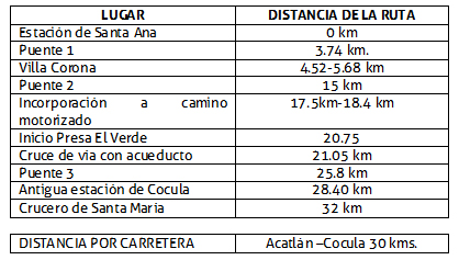
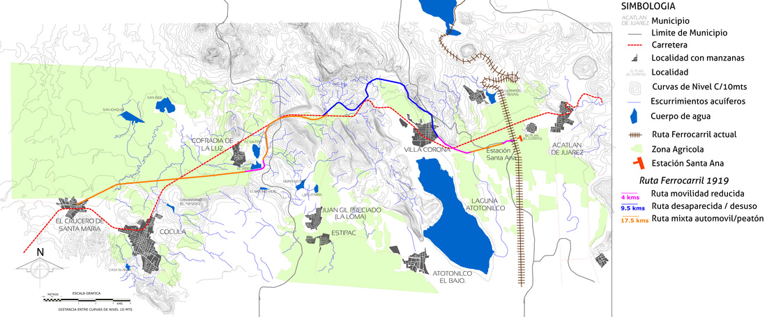
Plan D-04 | Distances and municipal boundaries
This map is into municipalities or countys, according to the old section of the Chamela's railway as the kilometers of route corresponding to each county, in which Acatlán de Jusrz county has a short extension between Santa Ana Station and Villa Corona county limit. The distances for each county are:
Acatlán de Juárez county: Santa Ana station and junction with road. About 1 km.
Villa Corona county: From the end of km. 1 to km 17.5 with sections of gap and junction roads, fields and Villa Corona City. This route mainly passes through cane fields
Cocula county: From kilometer 17.5 to Km 31 and until the end of the route in 'El Crucero de Santa Maria' town. This route includes dirt roads, junctions with roads, a dam with its aqueduct and cane fields.
The rout starts in the Santa Ana station and heading to the Cocula city limits.
km 0. Santa Ana station is considered the starting point.
The route coninues along the Atotonilco Lagoon To the urban area of Villa Corona city at km. 5. In this section the route passes through cane plantations with significant landscapes to the region.
At km. 18 the route intersects with the road to Estipac, (La Cañada), With a MEX 80 and a small path that leads to small communities as Juan Gil Preciado y Estipac.
At km. 22, the route passes under the aqueduct located at the 'El Verde' dam. Continues to Cocula station through a short cruise with La Vega road, To reach 'Las Palmas Farm' where Was the old Cocula station and the end of the original route.
Near the route also the are important elements of heritage value, as diverse cane plantations and water sources that supplies the region.
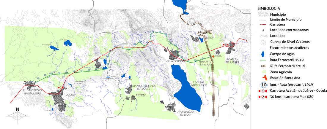
Plan D-05 | Interest point
The Acatlán de Juárez, Villa Corona y Cocula region is rich in water resources as reservoirs, springs, rivers, watersheds, streams, and dams. It's also a rich area in mineral due to it's hot springs throughout the area, mainly in Villa Corona. Besides the water resources, in this area you can find important heritage sites with cultural and natural atractions, among wich are:
|
In Villa Corona
1. Zarco Stream 2. Colorado Stream 3. La Compuerta Stream 4. Corral Falso Stream 5. Atotonilco lagoon (2) 6. Hot spring waters: Chimulco (aquatic center) Agua Caliente (aquatic center) El tular Las delicias (aquatic center) Las brisas (aquatic center) Las termas (aquatic center) Los Veleros 7. Estipac dam 8. la Cañada dam 9. La Guitarra (3) 10. Montenegro dam (4) 11. Ciénaga dam 12. Las Tuzas dam 13. El Tecuán dam 14. El Verde dam (5) |
In Cocula:
Camichines, Prieto and Los Duendes streams El Saucillo and El Horno springs Cofradía, El Molino Viejo (6), Palo Verde (5), San José de la Sauceda (8), San Joaquín (9) San Antonio (10) lagoons In Acatlán de Juaréz: Acatlán river and the springs: El Cajón del Muerto y Charco Verde, and Hurtado, Presa Chica y Bordo de San Gerardo, Los hornitos (1) dams Tourist points in the study area Agua caliente Aquatic center(11) Chimulco Aquatic center(12) Las delicias Aquatic center(13) El tular Aquatic center(14) Las cuevas Aquatic center(15) Tilapia fish restaurant (16) Horse farm (17 |
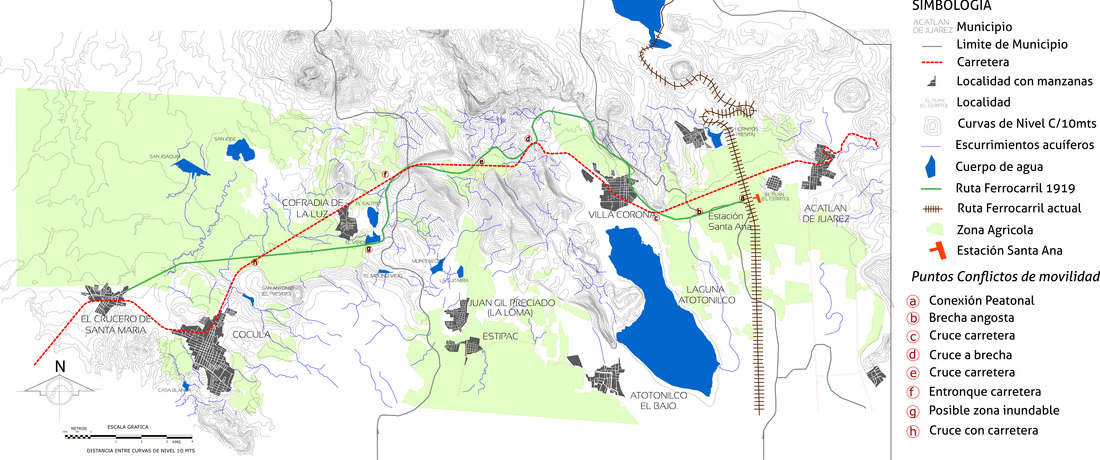
Plan D-06 | Points of possible conflicts of mobility and continuity ofthe route.
1.- Road junction 1.
There are three junctions of the old railway route with the highway that comunicate the three municipalities. The first junction is located at km. 4 of the old path and crosses the Road with heavy vehicular traffic making it very dangerous so the proposal must ensure The safety and confort for the user.
2.- Aqueduct in 'El Verde' .
This is an area where specific Studies should be conducted due to the instability of the of a soil flodded several times and seasonally rising levels of the dam. Also the compaction of the original board where The tracks were is deteriorated.
3. Road junction 2
Is located near the road that conects the towns of Juan Gil Preciado and Estipac.
4. Road junction 3.
This junction is located in mk. 26 in Cocula county, near to the old railway station.
Plan D-07 | Types of circulation / current mobility
This map is the analisys of current traffic along the route through wich passed the old railway divided Into three sectors made up for:
a) Abandoned route: Where there is no trace of the path due to the original route is obsolete and whose surface has deteriorated and eroded over the time.
b) Automobile and bicycle shared path: this is the section where it joints the route of old railway and the federal highway is being expanded to eventually afect the greenway project.
c) Bycicle or pedestrian path: for ciclyng and walking with less risk and easily because it mostly consist of stretches of unpaved road with less trafic of cars and trucks.
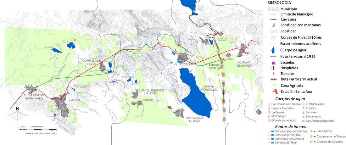
Plan D-08 | Cultural heritage in the study area.
The most representative elements of cultural heritage in the study area are:
a) Cocula station: former railway stwtion located neart the town named 'Crucero de Santa María', in Cocula county.
b) Hacienda la Cofradía: Ex Hacienda located in the small town of 'La Cofradía de la Luz'. it has a main building that has exceptional value.
c) ElThe aqueduct at acueducto de la presa El Verde: Los acueductos en la actualidad cumplían una importante labor ya que se encargaban de distribuir el agua a las cosechas de los habitantes e incluso llevaban agua a las haciendas y casas de l as personas. Este acueducto en particular es muy interesante ya que por debajo de uno de sus arcos cruzaba la antigua vía de ferrocarril. Representa un elemento importante de valor patrimonial y paisajístico por el entorno natural en el que se encuentra.
d) Contexto urbano de Villa Corona. Una parte de la ruta original se encuentra dentro de la mancha urbana de dicha localidad.
c) Estación de Santa Ana: Esta estación es una de las más grandes en el estado de Jalisco[1] lo cual significa que tenía un movimiento importante de carga y pasajeros.
[1] Solórzano Gil, Mónica, Rescate y conservación de las estaciones de ferrocarril en Jalisco. Op. Cit.

Plano D-09 | Tramos de recuperación de la ruta original
A lo largo del análisis puntual de la ruta antigua encontramos ciertos tramos con diferentes características los cuales se han categorizado y se les ha señalado de diferente forma para poder ubicar y analizar los diferentes problemas que presenta cada uno. Se ha dividido el trayecto completo en diferentes secciones que son la siguientes: