
THE CHAMELA RAILROAD
On October 26, 1889 President Porfirio Diaz approved the contract between General Carlos Pacheco, Secretary of Public Works and Mr. Gonzalo A. Esteva for the construction of a railroad line starting from Guadalajara ended by a party to the port of Chamela and the other in the city of Aguascalientes. The concessionaire could build on their own or supported by one or more companies organized for that purpose, and explode the railroad the same way for 99 years. It would define the outline, to be approved by the Ministry of Development, and agreed to start the work within one year and finish on 10 years, under penalty of forfeiture. The railroad would have warehouses, workshops, stations and a telegraph line parallel to the path.
On February 17, 1890, Governor Mariano Barcena said the State Legislature have madethe contract for the construction of the railway in the territory corresponding to Jalisco. In support of its decision, stated that while in other regions communications were becoming a major development, in the western line was only available to Guadalajara, being necessary to communicate this to the Pacific coast.
The line from Guadalajara to Aguascalientes would enable the products of Jalisco came north of the country, lightened by the freight savings that would result in the decrease of the distance. Governor Mariano Barcena announced that same year the general terms of the contract, which specified that it would be unavoidable, pass the path for Ameca and Mascota or Autlan and Lagos de Moreno in case the line does not come out directly from Aguascalientes.
The Chamber of Commerce said that there was no security on the part of entrepreneurs to the construction of the railway, the subsidy offered by the Government was excessive, that the Central Railway was forced to extend its line to the Pacific in eight years without subsidies, the difference of a year does not justify the expense, that could reach 4 or 5 million pesos of that time.
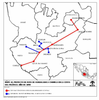
The possible line of the railroad route from Aguascalientes to Chamela was studied by engineer Charles F. de Landero who sought financial information and support. He proposed that the railroad depart from Guadalajara to the northwest, crossing the Santiago river near Tololotán bridge, and to continue on the northern side of the canyon until the Green river in the Nochistlán canyon to reach Calvillo lands.
The path of this route would include 145 kilometers in Jalisco, 35 km. in Zacatecas and 65 km. in Aguascalientes, with a total of 245 km, while the Guadalajara to Irapuatodistance was 259 km and from there to Aguascalientes, 233 km. being a total of 492km., so that it save 247 km of route. From Guadalajara, would start the track and rails to Cocula, to pass through San Isidro and to Sayula basin and then to the Ameca valley. Sayula area already developed the cultivation of sugar cane plantations and were beginning agave plantations to produce mezcal. Were known the large deposits of volcanic rock. The salt ponds of Tizapan, Zacoalco, San Marcos, Atoyac and Sayula propitiated by the evaporation of its waters, rich and abundant efflorescences of common salt and sulphate and sodium carbonate,this useful to make soap and one for preparing sodium sulfide, which is essential in the metallurgy of silver by leaching method.
In the mountains of Tapalpa, whose borders would approximate the route, had found sources of copper, iron, gold, silver and mercury near Chiquilistlán, small coal fields and in the mountains, iron minerals, housed in large forests pines, oaks. In the Ameca valley was land for corn and sugarcane breeding cattle, sheep and pigs, tanning industries andwool fabrics, and rehearsed the cultivation of the fine fiber ramie, silk plant species all introduced by governor Bárcena.
Ahualulco was one of the main centers for producing agave tequila and was expected to use the fiber for making paper from waste. Alkaline hot springs from Puerta de la Vega suggested to encourage walking, emerging forms of tourism. From Cocula following the trace to Tecolotlán, through fertile valleys, and from there to Autlan, or Ayutla to take the upper basin of the Ayuquilla river. Autlan Valley predicted that would acquire an extraordinary importance for the railways because it crossed a very mighty river and numerous streams. However, the passage of the Sierra de Perote was the greatest obstacle to the proposed railway.
On February 17, 1890, Governor Mariano Barcena said the State Legislature have madethe contract for the construction of the railway in the territory corresponding to Jalisco. In support of its decision, stated that while in other regions communications were becoming a major development, in the western line was only available to Guadalajara, being necessary to communicate this to the Pacific coast.
The line from Guadalajara to Aguascalientes would enable the products of Jalisco came north of the country, lightened by the freight savings that would result in the decrease of the distance. Governor Mariano Barcena announced that same year the general terms of the contract, which specified that it would be unavoidable, pass the path for Ameca and Mascota or Autlan and Lagos de Moreno in case the line does not come out directly from Aguascalientes.
The Chamber of Commerce said that there was no security on the part of entrepreneurs to the construction of the railway, the subsidy offered by the Government was excessive, that the Central Railway was forced to extend its line to the Pacific in eight years without subsidies, the difference of a year does not justify the expense, that could reach 4 or 5 million pesos of that time.
The possible line of the railroad route from Aguascalientes to Chamela was studied by engineer Charles F. de Landero who sought financial information and support. He proposed that the railroad depart from Guadalajara to the northwest, crossing the Santiago river near Tololotán bridge, and to continue on the northern side of the canyon until the Green river in the Nochistlán canyon to reach Calvillo lands.
The path of this route would include 145 kilometers in Jalisco, 35 km. in Zacatecas and 65 km. in Aguascalientes, with a total of 245 km, while the Guadalajara to Irapuatodistance was 259 km and from there to Aguascalientes, 233 km. being a total of 492km., so that it save 247 km of route. From Guadalajara, would start the track and rails to Cocula, to pass through San Isidro and to Sayula basin and then to the Ameca valley. Sayula area already developed the cultivation of sugar cane plantations and were beginning agave plantations to produce mezcal. Were known the large deposits of volcanic rock. The salt ponds of Tizapan, Zacoalco, San Marcos, Atoyac and Sayula propitiated by the evaporation of its waters, rich and abundant efflorescences of common salt and sulphate and sodium carbonate,this useful to make soap and one for preparing sodium sulfide, which is essential in the metallurgy of silver by leaching method.
In the mountains of Tapalpa, whose borders would approximate the route, had found sources of copper, iron, gold, silver and mercury near Chiquilistlán, small coal fields and in the mountains, iron minerals, housed in large forests pines, oaks. In the Ameca valley was land for corn and sugarcane breeding cattle, sheep and pigs, tanning industries andwool fabrics, and rehearsed the cultivation of the fine fiber ramie, silk plant species all introduced by governor Bárcena.
Ahualulco was one of the main centers for producing agave tequila and was expected to use the fiber for making paper from waste. Alkaline hot springs from Puerta de la Vega suggested to encourage walking, emerging forms of tourism. From Cocula following the trace to Tecolotlán, through fertile valleys, and from there to Autlan, or Ayutla to take the upper basin of the Ayuquilla river. Autlan Valley predicted that would acquire an extraordinary importance for the railways because it crossed a very mighty river and numerous streams. However, the passage of the Sierra de Perote was the greatest obstacle to the proposed railway.
De Purificación a Chamela should lay the rails through the wide canyons of the mountain range, whose main peaksare the Panal y el Huehueton and to continue to the sea following the slope of hills increasingly high. The branches would be expected from Cocula to Ameca, with the possibility of extending it for Ahualulco and Etzatlán of a point on the Sayula basin to Zacoalco, from Tecolotlan or Ayutla to Mascota to develop the mining districts of Los Reyes, San Sebastián, Cuale, Aranjuéz, Real Alto, El Desmoronado y Navidad; and from Chamela to the upper valley of Tomatlán. In Chamela, for the first stage would be a good enough dock in Las Rosadas, and another smaller un Perula or El Pulpito. On January 25, 1917 the Ministry of Communications and Public Works, headed byManuel Rodriguez Gutierrez, made a contract for the construction of a railway, starting from Acatlan de Juarez, from the Santa Ana station[1] which would pass through Autlan and end at the port of Chamela. The state would beginthe work before mid-year, build 20 kilometers in 15 months and after 31.5 km. in 12months to complete the line.
The length of track was estimated in 673 km of which 289 km. corresponded to the route from Aguascalientes to Guadalajara and 384 km. from Guadalajara to Chamela, including the branch to Ameca. The project was put into work although partially and considering other bases, in 1917, suffered setbacks because of the Mexican Revolution, was revived in 1919 and was finally possible to make the trains run from Acatlan de Juárez to Cocula. The service had less and less success and finally in 1928 or 1929 were dismantled the tracks to sell such as scrap iron rails.
In early March 1917, Venustiano Carranza, accompanied by General Manuel M.Dieguez, governor and commanding general of the State, inaugurated the construction of the road to Chamela. "There were those, indeed propitious time to undertake an enterprise of such magnitude, as the country was on the struggle of the revolutionary factions".[2] However, he finally managed to build the line to Cocula. In the newspaperThe Reporter, dated April 1, 1919 [3] mentions that he made "Sumptuous reception inCocula to Mr. President." The article explains how the new road was inaugurated withgreat festivities. The article reads:
...“The presidential train arrived in this town at three in the afternoon, without any novelty in the way. The distinguished travelers were received at the station by the Municipality, the organizing board of this celebration and several prominen ladies of the town."
The train carrying the General Dieguez was followed by the train that was available to thepublic of Guadalajara, after which, came gondolas to transport cars.
Lines below, the article mentions that:
… Cocula was colorfully decorated. Three arches were built in different streets of the townand several were raised in
nearby towns.
In the same newspaper but dated April 3, 191[4], reports that: "Mr. President returned to the capital carrying a great impression of his trip to Jalisco”
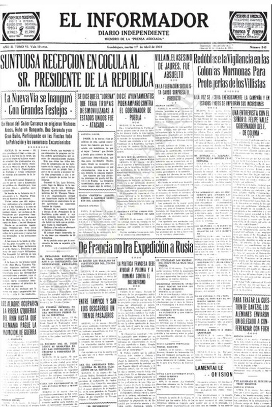 The Informador Newspaper on 1 January 1919. Post on the front page of the arrival of the railroad to Cocula |
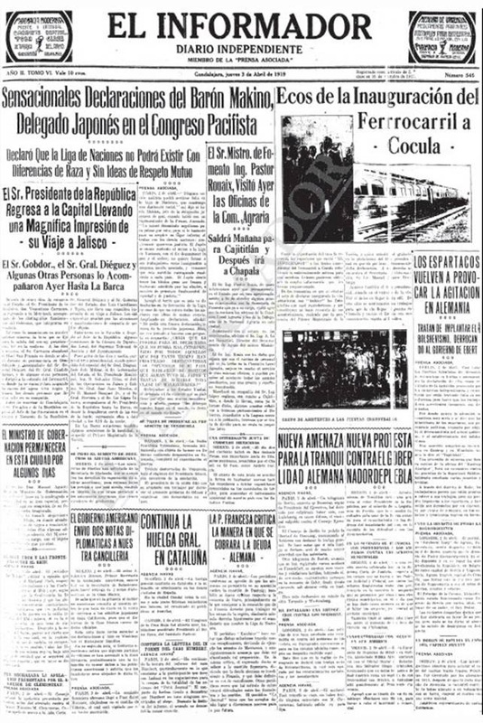 El Informador Newspaper of January 3, 1919 with a follow-up note about the opening of the railway in Cocula two days ago. |
The operation of the railway had to be rickety and unstable, because almost nothing hadto be transported in such a short span. In the early twentieth century in the papers the issue of construction of this railroad did not seem to interest the public. But if it became notice when in August 1926 was considered for the first time to suspendthe service that time the trains ran only between Santa Ana (Acatlán) and Santa Maria stations, and so more and more irregular. In the course of one month only moved seven vans loaded with lime stones from the nearby sites.
Products from farms near the railroad could not have access to the stations because of the heavy rains that flooded the wagon roads, and each time was less and less the number of passengers using the train.The government received almost no income of the railroad and had decreased to a minimum its staff, so that the superintendent was also a station master, conductor, auditorand often Courier Express. [4]
Members of the Western Railroad Party tried to stop the failure and cancellation of the Railways of Jalisco, whose only line was in crisis. Sought to avoid the stagnation of what was still called "Railroad to Chamela.".[5]

Railway Map of Jalisco, Line to Chamela. General Design of the line indicating the Progress that date. Signed in Villa Corona on February 28, 1919. Source: Historical Archive of Jalisco
From 1926 to 1932, years for the "Cristera Rebellion," when there were several national political crises and the global economic downturn, the Government of Jalisco had 10 presidents. During this period agriculture declined, government revenues decreased, many employees were laid off, several properties were sold and dismantled public road, which began to build from the time of General Dieguez bound for the Pacific. This has already sensed the February 2, 1928, when the Governor said that the Railways of Jalisco, were practically bankrupt, because in the course of a year the service was suspended five months.
Thhus ended the Chamela rail project, but the purpose of shortening the road from the westto the Midwest still remained latent until years later. If the railroad had been built to Chamela, might have changed the route of the South Pacific northwest coast of Mexico, and the incorporation of the Jalisco coast to the economic movement of the center of the country would be in place since a long time ago, and communications network from the railway line would have linked that region in all directions, as the principal axis on the railway line to Chamela .[6]
Thhus ended the Chamela rail project, but the purpose of shortening the road from the westto the Midwest still remained latent until years later. If the railroad had been built to Chamela, might have changed the route of the South Pacific northwest coast of Mexico, and the incorporation of the Jalisco coast to the economic movement of the center of the country would be in place since a long time ago, and communications network from the railway line would have linked that region in all directions, as the principal axis on the railway line to Chamela .[6]
[1] Leaving from the Santa Ana station on the road to the National Railways of Mexico on the route from Guadalajara to Manzanillo.
[2] Diversos documentos y datos relativos al Proyectado ferrocarril de Chamela a Aguascalientes, México, 1890, edición facsimilar, Introducción por José Rogelio Álvarez, Guadalajara, México, 1982. p. 10
[3] Periódico El Informador, Guadalajara, Jalisco, 1º de abril de 1919.
[4] Diversos documentos y datos relativos al Proyectado ferrocarril de Chamela a Aguascalientes, Op. Cit. p. 11
[5] Diversos documentos y datos relativos al Proyectado ferrocarril de Chamela a Aguascalientes, México, 1890, op. cit., p 22
[6] Proyecto de ferrocarril Tetitlán-Puerto Vallarta. Estudio económico. Comisión de Planeación de la Costa de Jalisco. Guadalajara, 1958, p.8
